XYZ BIMReferences · Scan-to-BIM
PTENDE
As-built survey · Scan-to-BIM · Heritage

Existing buildings, exactly as they stand.

Selected references 2020–2026, Germany & Portugal: from laser scan to as-deformed drawings, BIM models and web viewers. All references are anonymized — complete drawing sets available on request.

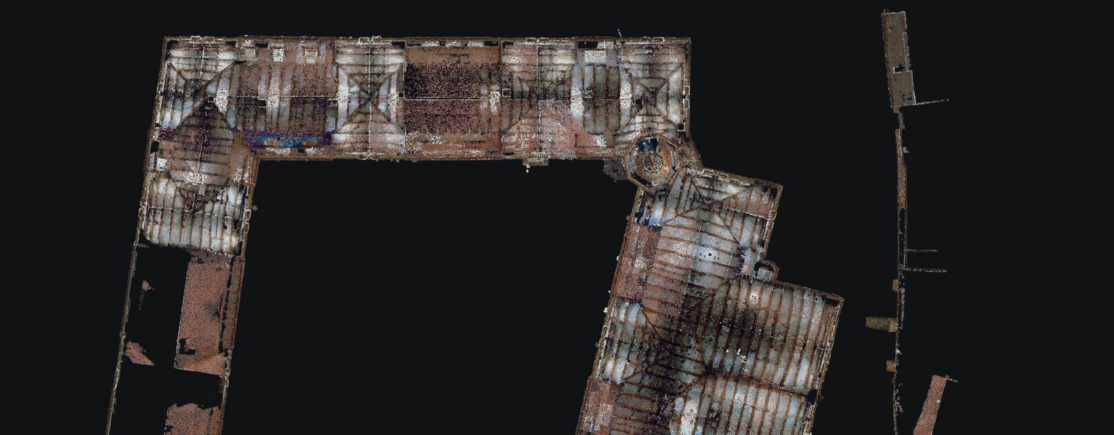
Registered point cloud of a baroque hunting lodge, top view
Registered point cloud · baroque hunting lodge Capture: V-Team GbR
Accuracy · USIBD LOA

Accuracy: what we commit to

Accuracy is a standard deviation. We work to the USIBD Level of Accuracy specification (C220) and DIN 18710, and state both quantities the standard separates: the measured accuracy of the survey, and the represented accuracy of the drawing or model that comes out of it.

LOA 10
> 50 mm
Organic or heavily deformed elements, normalised in the model.
LOA 20
15 – 50 mm
As-deformed BIM modelling — roughly 90 % of elements.
LOA 30
5 – 15 mm
Direct 2D on the cloud, in the section plane. Registered cloud.
LOA 40
1 – 5 mm
Single station before registration. Not represented at this band.
LOA 50
< 1 mm
Industrial metrology, outside building documentation.
Measured: on site, a terrestrial scanner delivers LOA 30–40. Represented: BIM model at LOA 20 (organic LOA 10); direct 2D from the cloud up to LOA 30.

Own commissions

01

Baroque hunting lodge

Saxony, DE · 2024
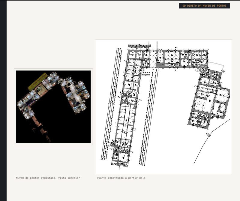
Registered point cloud and the plan constructed from it

Complete as-built survey of a baroque hunting lodge: terrestrial laser scan across five levels, some 30 GB of raw data. The drawing set was constructed directly on the registered cloud, with spot levels, reflected ceilings and the real, out-of-square wall geometry.

Typology
Listed heritage · Palace
Deliverables
Laser scan of all storeys, plans, elevations, sections, mesh model
Scale
1:100
Accuracy
up to LOA 30
Role / Execution
Subconsultant · geodetic engineering office
02

Mine headframe and shaft hall

Erzgebirge, DE · 2022–23
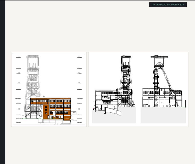
Elevations and sections of the mine headframe

As-built survey of a uranium-mining shaft complex: a 50 m steel headframe over the shaft hall, documented across ten levels. Elevations and sections were derived from the element model, the basis for the monument's remediation design.

Typology
Industrial heritage · Mining
Deliverables
Plans basement to level 8, elevations, sections
Scale
1:100
Accuracy
LOA 20, organic LOA 10
Role / Execution
Subconsultant · geodetic engineering office
03

Turn-of-the-century courtyard works

Berlin, DE · 2023
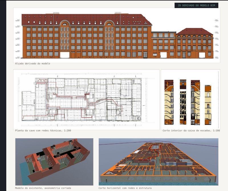
Model-derived elevation and plans of the courtyard works

As-built survey of a listed courtyard works arranged around three yards: some 120 m of street frontage, six storeys and a vaulted souterrain. The point cloud produced an element-based Archicad model, and the model the complete drawing set.

Typology
Industrial heritage · Courtyard works
Deliverables
Plans basement to attic, four elevations, four sections, stair-core interior sections, as-built model
Scale
1:200 / 1:100
Accuracy
LOA 20, organic LOA 10
Role / Execution
Subconsultant · geodetic engineering office
04

Baroque high altarpiece

Northern Portugal · 2026
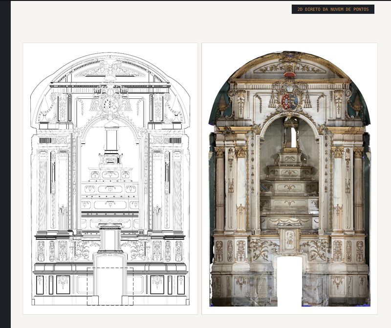
Line drawing and orthophoto of the baroque altarpiece

Documentation of a baroque altarpiece for conservation. Photogrammetric capture produced a high-resolution mesh and from it the orthophotos; the line drawing was constructed directly on the orthophoto: front, rear and pelmets, losses included.

Typology
Heritage · Gilded woodwork
Deliverables
Orthophotos 700 dpi–2k, as-deformed line drawings, mesh
Scale
1:20
Accuracy
up to LOA 30
Role / Execution
Subconsultant · geodetic engineering office
Collaborative / Subconsultancy

05

Renaissance university building

Lower Saxony, DE · 2020
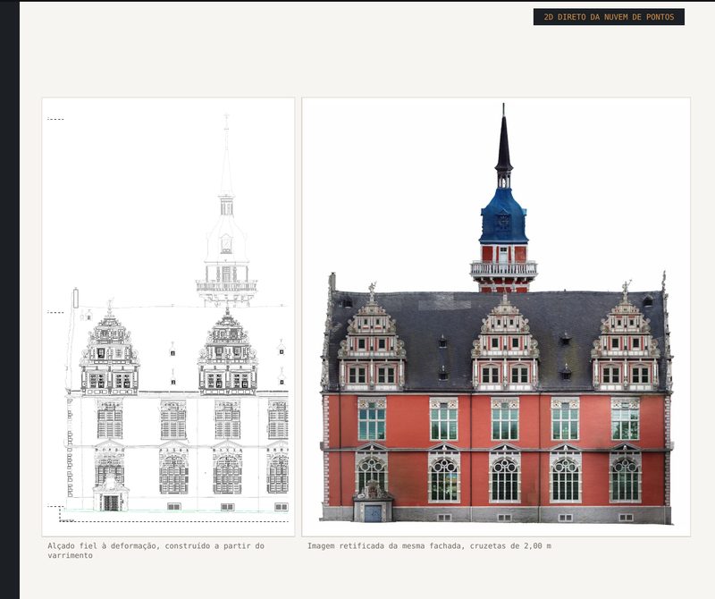
As-deformed elevation and rectified image of the Renaissance façade

Façade survey of a late-Renaissance university building with scrolled gables and a tower lantern. The elevations were constructed straight from the scan and served as the geometric basis for the damage mapping of the restoration.

Typology
Heritage · Façade
Deliverables
Façade elevations and rectified image plans for damage mapping
Scale
1:50
Accuracy
up to LOA 30
Role / Execution
Carried out at BGIS GmbH · evaluation & drafting
06

Roof structure of a town church

Lower Saxony, DE · 2021
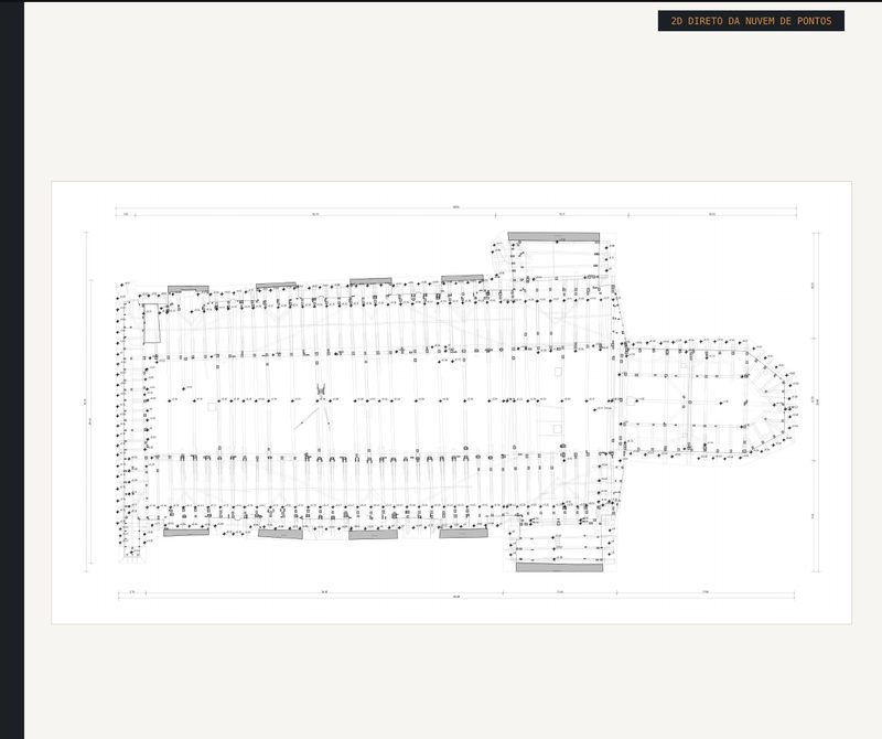
Roof-frame plan of the church

Survey of the historic roof structure over nave and chancel. Every rafter, collar beam and brace was recorded individually from the point cloud, the basis for the structural assessment of the timber frame.

Typology
Heritage · Structure
Deliverables
Roof-frame plan, spot levels, rafter layout
Scale
1:100
Accuracy
up to LOA 30
Role / Execution
Carried out at BGIS GmbH · evaluation & drafting
07

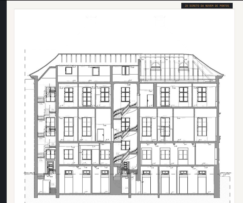
Inner-city block, as-built plan

Berlin, DE · 2021
Longitudinal section of the residential building

As-built section through an inner-city residential building: five storeys, a stair core with winding flights, a converted attic and rear balconies. Every window and door opening carries a measured level.

Typology
Housing · As-built
Deliverables
Longitudinal as-built section, storey and sill heights
Scale
1:50
Accuracy
up to LOA 30
Role / Execution
Carried out at BGIS GmbH (part-time) · evaluation & drafting
08

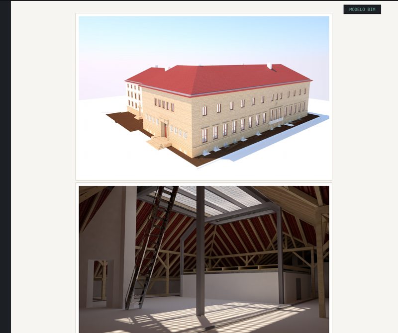
Gründerzeit housing block, BIM model

Berlin, DE · 2022
BIM model of the Gründerzeit housing block

The survey produced an element-based model of the whole complex: façades, roofscape and courtyard. 2D drawings derived from such a model are consistent and queryable, but sit one accuracy band below direct evaluation.

Typology
Heritage · BIM model
Deliverables
Element-based as-built BIM model, visualisation
Scale
LOD 350
Accuracy
LOD 350
Role / Execution
Subconsultant · geodetic engineering office
Research & beyond the drawing

R/01

Mesh geometry as BIM

Scan-to-MeshBIM: point cloud, deviation map and IFC model of the Emona city wall

How do you model an element with no planar surfaces — a ruin, a weathered wall crown? The subject of the European Master in BIM (BIM A+) thesis: Scan-to-MeshBIM in five stages, from capture to IFC, applied to a section of the UNESCO-protected Roman city wall of Emona in Ljubljana.

Programme
European Master in BIM (BIM A+) · UL FGG Ljubljana, 2025
Case study
Roman city wall of Emona · UNESCO
Topics
LiDAR · fotogrametria · quad mesh · IFC4 · openBIM
Publication
ptBIM 2026
R/02

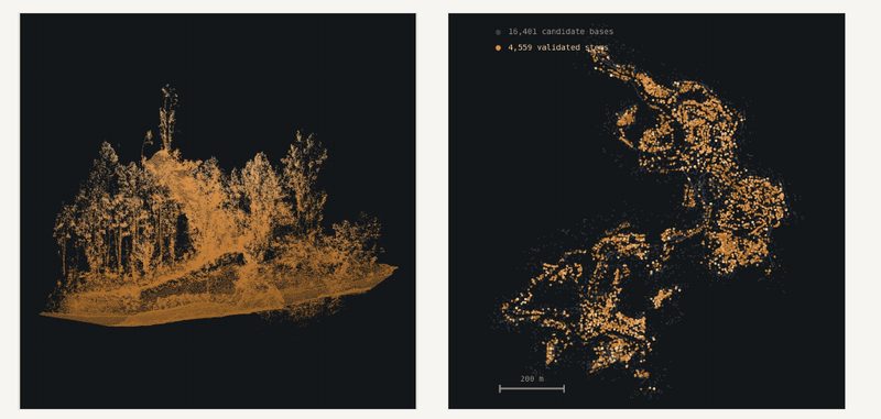
The point cloud as a set of measurements

SLAM point cloud of a forest stand and stem map

Not every point cloud ends as a drawing. For a forestry pilot we built our own processing chain: from a SLAM survey of the stand, individual trees are detected and the diameter at breast height of each stem is measured. The result is an inventory of coordinates, diameters and quality metrics.

Candidate bases
16 401
Validated stems
4 559
Area
62,7 ha
DBH range
8,0 – 80,0 cm
↘ Contact

Complete drawing sets on request.

For any reference we can share complete drawing sets, point-cloud extracts or IFC samples.

Request references What does it cost? · Scan2BIM estimator